Moon Lake County Park
GPS coordinates and links
Please click on the following link for GPS-Coordinates.net
Click here for gps-coordinates.net (will open in new window)
Please Click on the following like for Google Maps
Click here for Google Maps (will open in new window)
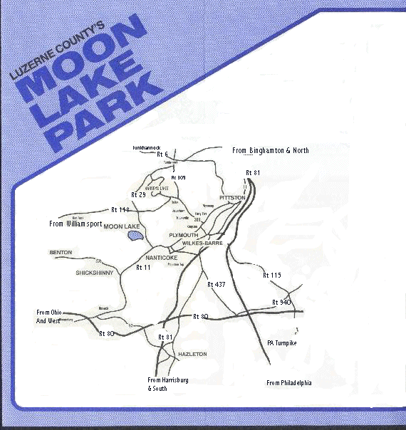
From Interstate 81
Take exit 164, Pa Route 29 N/South Cross Valley Expressway toward Nanticoke, go 5.2 miles. Pa-29 N/South Cross Valley Expressway becomes a ramp (stay straight) and merge onto US Route 11S / 29N, go 1.2 miles through West Nanticoke and turn right onto Route 29N, go 6 miles and make a left at sign for Moon Lake Park. This will be Moon Lake road, go to top of hill and bear left and follow into park..
From Route 118
Take route 29S from RT 118 / RT 29 intersection and go 4.5 miles and turn right at sign for Moon Lake Park . This will be Moon Lake road, go to top of hill and bear left and follow into park.
Alternate route, If you are using the directions above from route 81, below is a alternate route that will get you to our flying site. This route should be used when Rt 29N is closed for any reason.
At the intersection of Route 11 and Route 29 N instead of making a right onto Route 29 N stay on Route 11 S and go 3.0 miles and make a right turn on the main road in Hunlock’s Creek (There is a old Post Office on the corner that is not in use), go one half mile and turn right on Hartman Road, go 5.2 miles and make a right turn on Moon Lake Road and follow into Park. This detour is only about two miles longer than coming up Route 29 N; Hartman road is narrow and crooked but should not be a problem.